Vassijaure - Abisko

Nearing the end of April, the nights were only about -5°C to 0°C cold, making winter camping with my two non-winter sleeping bags way more comfortable. As we had a weekend off once again, me and two study friends set out for the first bro-trip in this season. This time we planned to start near the Swedish-Norwegian border at Vassijaure or Låktatjåkka, hike into the mountains and reach Abisko one day later.
The weather was once again not that awesome - what started as light snowfall soon became a full-scale whiteout forcing me to use my mobile's GPS way more often than I'd have liked to. Especially in these for April unexpectedly cold weather conditions.
Anyway, we were not the only ones to start here - two middle-aged swedish guys wanted to go to Låktatjåkkastugan as well. Looking at our snowshoes (they of course had cross-country skis), one of them looked at me with big eyes and asked: "You wanna go into the mountains with those?" - "Yeah, of course" - Silence. We left the guys fumbling with their clothes and started the hike through wind and snowfall, first break was at a small triangular shaped hut. When we were nearly finished with resting and snacking, the other two guys with their skis came. I had expected them to overtake us only minutes after we started, as there were quite some flat parts as well, but seems like they weren't either experienced or fit enough to do so.
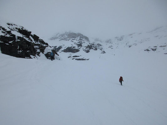
The weather got worse all the way up to the mountain hut, we couldn't even see the hut itself until it was as close as about 100 meters. Perfect conditions for mountain hiking. The hut was full to the roof with people, mostly skiers going from Låktatjåkka to Björkliden or by snowmobile drivers going the same way. We had some lunch and decided to continue, even though the weather didn't look promising. But it's hard to tell how many clouds there are if you can't see your hand in front of your eyes.
So we packed our stuff and left the well worn path to continue south into the mountains, aiming at surrounding a set of 1400 m peaks before reaching the small hut at the tiny Kåppatjåkka lake. With a bad view, the path on the map not being in my GPS map and a difficult territory, we soon dropped that plan and went for the top of the three 1400 m peaks. The ascent was very snowy and accompanied by a few phases of complete whiteout, confusing the mind and making you feel sort of unbalanced - it's impossible to tell the steepness of a slope right in front of your feet. It was definitely interesting to experience this, making me realize how dangerous whiteouts can be - especially without a GPS device and if it lasts for several days.
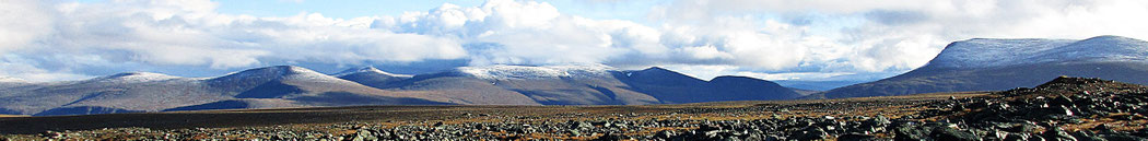
When we reached the top, it finally started to clear up, just at the right moment. The mountains around us started to unfold as the clouds moved away, providing a nice panorama. From there, we descended down to the small shelter/hut, which we had to dig free before we could even enter it. Considering the distance we covered already, it shouldn't be hard to catch the morning bus from Abisko to Kiruna, so we decided to not stay here and instead cross to the Kårsavagge valley and camp there.
The descent down to the valley was incredibly steep. I still have no idea how snowmobiles manage to get up this slope, or down. I would shit my pants. In a mix of walking and sliding, we finally reached the bottom and set up our tents after admiring a beautiful sunset coloring the mountaintops on the other side of Abiskojåkka red.
After the coldest night in April (at least statistics said so, and my freezing ass was sure about that too), we hiked the last kilometers to the Abisko Turiststation in bright sunshine.